WESTMORELAND COUNTY, VIRGINIA
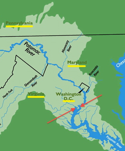
We will come back to the water park in just a moment. Bring your swim suits and golf clubs should you come looking for Peeter Smith and Stephen Robinson of the Aunt Robbie tree! Putting things in perspective, in the map below we have the present day state of Virginia and a second arrow pointing at land that is known as the Great Neck of Virginia. The Great Neck includes land between the Potomoc River and Rappahannock River. The land includes the counties of Westmoreland and Northumberland, among others. The Smith and related families worked their way up this peninsula from right to left, southeast to northwest over the course of a century from 1650 to 1750. See more specific maps related to actual Smith properties below.
The map below hones in on the Great Neck Peninsula showing the several counties that occupy the peninsula between the Potomoc and Rappahannock Rivers. Our Peter of Yeocomico (1663-1741) lived near the Westmoreland County line with Northumberland County. I will zoom in all three of his purchases in the maps below.
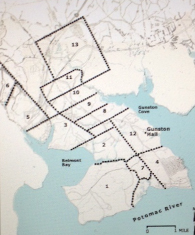
With Westmoreland in mind we will now zero in on several of the plat maps that identify properties our great grandfathers owned in the period from 1650 to 1750. The map below pinpoints the Mason Neck, also known as the Doegs Neck in 1650. It was on the Doegs Neck that Peeter Smith purchased 500 acres alongside fellow speculators who would be neighbors and friends through life. Purchasing 500 acres on the north edge of Peeter’s deed was one Stephen Robinson, an apparent great grandfather to my own Aunt Robbie.
It was on the Doegs Neck that Peeter logged in his first deed of land as a matter of public record. The plat map below reveals his neighbors and fellow speculators in 1657. Peeter purchased lot 10. The property is presently the home of the Pohick Bay Golf Course and Pirates Cove Water Park. For more information on this division of land on Doegs Neck please see the related blog.
Peeter and his son Peter Jr. and their families also developed properties to the south of the Doegs Neck on Nominy Bay and the shores of the Nominy and Yeocomico Rivers. N0miny Bay is depicted below, pinched between the two red arrows of the graphic below. Nominy is also spelled ‘Nomini’ in early records and deeds.
A plat map that I have developed from the compilations of others, using technology (Google Earth) not available to my predecessors, is submitted below. I was struck by the fact that so many of Peeter’s neighbors were men who had risen up in rebellion against Lord Calvert in Maryland that I have symbolized their plantations with red flames. They did torch a few buildings across the river in Maryland before they fled, with amnesty, from Maryland. For more about the antics of these pre Revolutionary War renegades please click on this link.
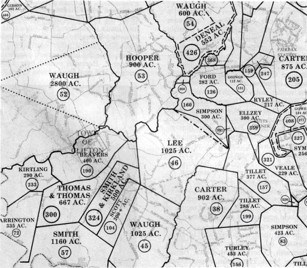
Peter of Yeocomico (Junior) purchased land along Bull Run in 1715 and this land provided the home plantations for several of his sons including our Great Grandparents James Smith and Elizabeth Presly Taylor Smith. The plat map for the Bull Run properties, just to the south of present day Clifton, VA includes the names of many illustrious Virginia families including the filthy rich Carter family, of tobacco industry fame. With this map, and using Google Earth, I am able to drive right to the front lawn of the property. And there I would find an elaborate series of soccer fields. For more information about this endeavor and the families involved please click on this link our Bull Run Family.


