
Gen 10: The Immigrant Ancestor – Looking for Peter Smith’s Father
An immigrant ancestor is an important person in any family tree. The immigrant ancestor is the one who got off the boat and stepped foot on North American soil for the first time. Male and female immigrant ancestors are equally important, but I have noticed a proclivity for family historians to point to the men in their family trees as the immigrant ancestor. In any case, I am at a loss when it comes to identifying Peter Smith as an immigrant ancestor in our family tree. It is very possible he was born in Virginia or Maryland for that matter. Perhaps his father or grandfather was the immigrant ancestor. There are numerous and excellent birth records available for discovery in the colonial archives. Unfortunately, there are no neon signs pointing toward the Smith immigrant ancestor.
While there is a wealth of documentation that has survived the centuries, not all paperwork (documents and official records) survived. There are also major gaps in the archives, especially in those counties whose courthouses were vulnerable to British attack in the War of 1812 or to the massive destruction brought about by our own American Civil War Between the States. Courthouse fires destroyed some official records. During the civil war soldiers in both blue and gray needed to create fire for warmth and the courthouse records provided the necessary fuel. Thus far, nothing definitive has surfaced that would allow someone to proclaim they have found Peter’s place and time of birth, let alone identifying for certain, his parents. There is no shortage of conjecture and I will add my own two shillings.
Operating on one assumption that Peter Smith was born in the British Isles and came to America required that I search birth and marriage records for Great Britain and Ireland. I had to scour ship manifests available online. A manifest identifies all passengers on a ship.
Several manifests (passenger lists) reveal the arrival of a ‘Peter Smith’ in the latter half of the 17th Century. There is no other shred of evidence that would allow me to proclaim, with certainty, that any one of the newcomers is our immigrant ancestor. Furthermore, if I find a Peter Smith getting off the boat in Maryland or Virginia, I cannot assume it was his first trip across the ocean. Family business did find colonists returning to European ports at one point in a decade and back to the colonies at another point in time, thus showing up on a ship manifest more than once. Such trips were made for business reasons or simply pleasure and were not uncommon. In fact, heirs often ventured across the sea to settle issues related to family estates. Sons would sail the ocean, attend college or close a business venture.
Many online trees insist that Peter of Yeocomico’s father was also a Peter Smith. Family historians, hungry to find a ‘Peter Smith’ found one born in England in 1646 and anointed him the father of Peter Smith of Yeocomico. Marriage certificates indicate that a Peter Smith married a Jane Barnes in London in 1661. It was assumed Peter born in 1646 married Jane and Jane was anointed as the mother of Peter of Yeocomico. Research concluded with the finding of a record of a Peter Smith arriving in Maryland in 1683. He was labeled Peter of Yeocomico. This research assumed there was only one Peter Smith in the British Isles or the colonies in the mid-1600s. There have been too many Smiths in the world for me to readily accept the previous findings as conclusive. Heck, there are 50,000 Steve Smiths today in the midwestern states alone. I could create an interesting autobiography if I took bits and pieces of the lives of the many Steve Smiths.
This is where the detective work begins. I love Sodoku puzzles. I just don’t know how to spell Sudoku without a spell checker. I enjoy crossword puzzles and crypto-quotes. I just can’t master them the way my mother-in-law does. I have mastered the Rubik’s Cube, just not in 5 seconds and I needed an operator’s manual. So, I have a natural desire to solve a puzzle, riddle or crime scene. Tracking Peter Smith has been an unresolved puzzle. We will, of course, follow the money and begin with one of the earliest deeds I can find referencing Peter Smith.
In July of 1657, a Peeter Smith secured 500 acres of land in Virginia:
“Peeter Smith, 500 acs. in Petomeck fresher, N. Ely. upon a creek above Col. Speakes land & S. Ely. upon land called Gosnells land. 15 July 1657, p. 117, (174). Trans, of 10 pers: Rob. Clerke, Rob. Holmes, Math. Wardle, Anne Hamond, Tho. Dorwood, Anne Forty, John Ayres, Francis Ayres, Richd. Hardman, Tho. Webster.”
After reading a ton of deeds and with the help of online resources I have learned to translate the above paragraph as follows:
Peeter Smith secured a deed for 500 acres of land in the Potomac River marsh. The boundary runs Northeasterly from the marsh and along a creek that is found above (or inland) from Colonel Speake’s property and then South Easterly to the land owned by Gosnell. The deed, dated July 15, is found in the deed book for Westmoreland County on page 117, and identified as transaction number 174. The recorder of the deed then identified the method Peter used to pay for the property.
Per the head right system instituted by Sir Edwin Sandys in 1617, the British government gave each person who paid their way to the colony 50 acres of land. The monarch also gifted another 50 acres of land for each person a sponsor transported to Virginia. The recorder of this deed has noted the ten people Peter transported (trans). Note that Peter was not listed as one of the ten. This means that he was already present in the colony and not on board the ship. The ten people identified from Robert Clerke to Thomas Webster are not necessarily family members, cousins of any kind, neighbors or employees of Peter Smith. It is conceivable that some or all worked for Peter as indentured servants before earning their freedom. One thing is certain, Peter covered their ‘up front costs’ of getting over the ocean to Virginia. They billed the journey to his credit card. They were not necessarily all on board the same ship. One could check the ship’s manifests (passenger list) to see. Both Peter and the government kept their records as best they could.
This head right system had several advantages for all involved. It was a win-win situation for everyone. The British needed to populate the countryside of Virginia if they hoped to keep the Spanish and Dutch out of the area. They needed to arm the civilians against Native attacks, fortify the harbors and look for gold and silver. The British needed to avoid the mistakes they made early on in Maine, Roanoke and Jamestown. They needed to develop food sources, profitable crops and an economic system that could benefit London investors and provide tax coinage for the King. For Peter Smith it added 500 acres to his growing plantation system. For guys like Robert Clerke it provided an escape from British persecution, poverty, jail or simply an adventure in a new land and an opportunity to pursue a dream. It wasn’t perfect, especially if an indentured servant was in an abusive relationship with a master. Servants did violate the terms of their contract and sometimes ran away, just as a slave might do. Newspapers and postings in villages would notify the public of a servant’s crime and rewards were paid by our ancestors for the return of the runaway servant or slave. Courts would treat the servant as a criminal and mete out punishments that would add time to the servant’s obligation. We find both masters and servants in our family tree, and servants who became masters, and masters who were broken by war and became servants.
Another point needs to be made regarding spelling. The spelling of names varied wildly from Europe to America. French, Dutch, Gaelic, Italian and even English names were altered quickly by recorders who splashed letters on a page in a phonetic effort to gather the facts needed to fill in the blanks required by the monarch. Thus, a Gosnold could become a Gosnell in a land deed office, and a Gosnold on a wedding day. A Smith could be a Smyth in England, a Schmit in a Prussian principality and a Smith when arriving in Virginia. Even in their homelands, family spellings could vary from town to town and cousin to cousin. I have found brothers and sisters who each spelled their surname in a unique manner. Knowing the variations became important as I pursued a lost relative, a property that would help me find a homestead or a link that will help me close the door on an issue that needed to be resolved. I felt like Dog the Bounty Hunter at times, sniffing out a lead for an errant in-law, outlaw or prodigal son.
I know a Peeter Smith acquired 500 acres along the Potomoc River in 1657. I am also reasonably sure the Peeter Smith found in the marsh “near Gosnell” is not the same man as our Peter Smith of Yeocomico (Westmoreland). A person acquiring legal deeds to property in 1657 would have to have been of the legal age of 21, younger only if sponsored by a notable financier. This Peeter Smith would have to have been born no later than 1636. Our Peter Smith died in 1741. That fact was established in his will which is recognized as true. As sturdy a man as he might have been, he was not 104 at his death. True, it is possible he was 104, but it does not jive with the growth of his family, his children and their lives. The average colonial man died in his mid-forties.
While there is evidence of hearty stock in our Smith family dating back through the centuries, an age of 104 would be incredibly unusual. It is widely believed that our Peter Smith was born somewhere between 1663 and 1685. The exact birth year of our Peter Smith has become subject to the usual estimation process required when records are not available and family historians have to make things work.
In the book, Peter Smith of Westmoreland County, Virginia (died 1741) and Some Descendants, authors Richard Bender Abell and Wilmer Lane Smith present a thorough examination of records of Westmoreland County (primarily land deeds) from the mid-1600s to the mid-1700s which pertain to Immigrant Peeter Smith and our Peter Smith of Yeocomico (d 1741). The authors lament that neither Peter Smith is designated as a Junior or Senior. It is therefore difficult to determine which man is involved in land transactions. There are over 20 documents cited by Abell and Smith pertaining to either of the two men. The authors conclude that,“Consideration of all of the evidence suggests that the Peter Smith who immigrated to Northumberland (Westmoreland) County in 1651 and the Peeter Smith known to be living in that county in the years after 1651 are the same person.” They also believe the evidence strongly supports the notion that Peeter is father to Peter of Yeocomico. They do not insist on drawing that as a conclusion.
It may well be true that Peter Smith (b 1646) and Jane Barnes are the parents of Peter of Yeocomico. Peter (b 1646) is not the Peeter Smith who purchased properties in the ‘Petomeck Freshes’ in the 1650s or the better part of the 1660s. He would have turned 21 in 1667. But he doesn’t have to be ‘Peeter of the Petomeck Freshes’ to be our forefather.
My search for Peter Smith became an obsession. Curiosity got the better of me and the winter doldrums caused me to slip into a state of mind that made me unrecognizable to my friends. Cushy mocs replaced my heavy work boots, my wool pajamas stayed with me further into the day, a flannel bathrobe felt awfully comfortable into the late morning. Retirement was also taking a toll on me. Troubled, at first, by the stubble that was growing on my face I considered taking up bridge, or sheepshead, or euchre…. But alas! This guy Peeter Smith kept me awake at night and I had to find him before he found me. I settled into the several deeds at hand.
On June 15, 1684, a James Smith sold 100 acres of land to his brother Peter Smith. Here is how the actual transaction was written at the time and I quote:
“15 June 1684, James Smith of Westmoreland to my brother Peter Smith of Yeocomico, for valuable consideration—100 a. Nominy Forest bought of and adjacent to William Well. Witnessed; Rch. Bruckes, Rch. Belleman. Recorded May 1706.”
It is, thus far, the first mention of a ‘Smith’ that we know belongs in our family line in American history. There are other surnames found in our family tree that arrived in the new world before the Smith family. For example: the Davis family was trodding on New World soil in 1607 and the Stille and Von Kouwenhovens were firmly entrenched on Long Island in 1638. Montgomery and Swafford families may have been well established before Peter Smith ever settled in the Nominy Forest. Pilgrims arrived in Plymouth in 1620 and we can count some of them among our many times great grandparents as well.
Peter wasn’t the only 6 times great grandparent I had walking around on Earth in 1675. At that point in time there were 256 people on the earth who would have been able to walk into any ordinary (a pub) in Westmoreland and proudly display a photo of my sisters and I on an iPhone and boast, “These are my great great great great great great grandchildren! Ain’t they somethin’?” I’m just focused on finding this one guy in particular: Peter of Yeocomico, and all I want to do is ask him, “Who’s your daddy?”
From the 1684 real estate transaction we know Peter Smith had a brother James and they lived in the Nominy Forest. We know the area was called “Yeocomico.” You can Google the Nominy River and the Yeocomico Church and find the location for Peter’s early digs. His neighbors included William Well and witnesses: Richard Bruckes (Brooks) and Richard Belleman (Berryman). It is through the acquisition of the names of neighbors, the record of deeds and an understanding of geography that I began to pinpoint the homesteads of many of our ancestors.
Two factors regarding Smiths became important as I processed deeds. 1) There was a second prominent Smith family in Virginia whose paths did cross our family path. 2) There were other men by the name of Peter Smith in the archives. A tremendous effort has been made by many people sorting through the Smith families of Westmoreland County and beyond. One gentleman commented: “You have to be insane to research the Smiths of Westmoreland.” I have found that to be true and I have a counselor who would agree with the prognosis.
A second land transaction took place on February 21, 1691, when Peter Smith bought a
“parsel of land containing about 60 acres lying on the branches of the Nominy conveyed by… (George Searles) to Peter Smith by indenture 21 February 1691.”
Peter was on his way to building a plantation with scattered properties. He had at least 160 acres to his name and waterfront property on the beautiful Nominy River. But which Peter (father or son)? Peter of Yeocomico/Westmoreland was fathering children at this time and adult enough be purchasing properties. The Peter believed to be his father died in 1691. Was this purchase the last one made by a dying father, or the start of a series of acquisitions made by a son?
A man named George Searles owned lands in the neighborhood. He was either a resident or a speculator. Like Colonel Speakes in 1657 who owned scattered Virginia properties, George Searles (in 1691) also owned property in various locations. It was not unusual, in fact very normal, for family properties to be scattered across the countryside from Richmond, Virginia to Jamestown. I will be sharing plat maps that help us visualize the Westmoreland community in which Peter Smith resided.
Peter’s property holdings increased when his brother James died. The following record, found in Westmoreland County Deeds and Wills, Book No. 3, 1701-7, page 402, states that Peter Smith had a brother James. The record reads as follows:
“May 1706. Hannah Breel spouse to Henry Breel of Northumberland County, only daughter and child of the deceased James Smith of Westmoreland County, with the consent of Henry Breel, to Peter Smith. – Our interest in the land. Witnesses: John Davidson, Margrett Smith.”
Several new characters are added to the developing story line. From this transaction we learn that Hannah was identified as the only living child of a James Smith in 1706. Hannah was married to Henry Breel and Henry was from neighboring Northumberland County. Westmoreland County was carved out of Northumberland County in 1653. Hannah was surrendering her interest in her father’s land so that her Uncle Peter might own it. The witnesses include a ‘Margrett Smith.’ Who was she? Was she the wife of the deceased James? Was she Hannah’s mother, step mother? Was she the wife of Peter Smith? Or a sister? It is one of many pieces in a jig saw puzzle that tugs at my synapses like a level 5 Sudoku puzzle crafted by a math crazed Hungarian in a Budapest hotel, surviving on Långos, Pörkölt and Dreher Bak.
In 1712, Peter Smith of Westmoreland County, Virginia received
“1160 acres of land granted by the proprietors of the Northern Neck of Virginia by deed …bearing the date of 30th day of June 1712…”
This was the deed to the Bull Run properties that became the homestead for James and Elizabeth Smith. This deed eventually led to a breakthrough moment in the design of the present-day Smith tree that includes descendants James Smith and his son, Peter of Round Hill.
With his deed of 1160 acres, Peter’s plantation system expanded north and west into lands along Bull Run. This is the same Bull Run that would be trampled by Union soldiers retreating from Rebel forces at the onset of the Civil War, long after the Smiths had removed themselves to the far reaches of a growing nation. This is the Clifton property previously discussed. Let’s define that elusive term ‘Northern Neck’ as found in the 1712 deed.

The ’Northern Neck’ is a location name for the peninsula upon which we find the counties of Richmond, Lancaster, Northumberland and Westmoreland, Virginia. The land was bounded by the Potomac River on the north and the Rappahannock River on the south. King Charles II granted the land in 1660 to seven of his aristocratic cronies including Lord Culpepper, who eventually took over the entire operation for himself and his heir, Lady Fairfax. The Northern Neck included 5 million acres that extended well inland from the Chesapeake Bay including the headwaters of each river. Peter of Yeocomico secured 1160 acres of that property.
Peter Smith appears often in the early records of Westmoreland County, witnessing wills, appraising estates, buying land. But the place and year of his birth and the names of his parents remain a well-kept secret. Speculation runs rampant among descendants, each hoping to discover the Higgs Boson particle in the family tree. Most efforts to identify his mom and dad point to Peter’s birth in the vicinity of 1663. It is also believed that he grew up near the Yeocomico Church, at Kinsale, Virginia, specifically within Cople Parish.
If you take all those place names and drop a pin at each location on a Google Map you get a pretty good idea of the area he may have cruised at night as a teenager looking to impress the young ladies and carve out a name for himself. The peninsula was already populated with the great names of American colonial life. In his seminal work, History of Truro Parish, the Reverend Phillip Slaughter (1909) explains that
“Space between the rivers was called ‘Necks.’ Among the most historic of these was the Northern Neck, which included the princely plantation of Lord Fairfax. Within this territory were the seats of the Fairfaxes, Washingtons, Masons, Smiths and other leading families too many to mention, who dispensed an elegant hospitality.”
Those ‘too many’ to mention included Marshalls, Jeffersons, Monroes, Madisons, Custes, Randolphs, Lees, Lewis and Clark…. It was a veritable hodge podge of names leading to the trendy Founding Fathers.
Peeter Smith and Doegs Neck
In previous discussions I have provided examples of the verbiage produced by those madcap guys in the Virginia Colony deed offices. These authors of deeds, frustrated screenwriters whose writing skills failed Shakespeare’s talent contests, were often accused of creating descriptions of property lines that were foreign to even the finest minds of the colony. It was suspected at one time that they were nom de plume authors of the earliest versions of the Onion Newspaper. Witness the eloquent put down provided by George Mason IV, the author of the Virginia and American Bill of Rights, in his complaint to William Fitzhugh in the winter of 1787:
“You will find some Circumstances in this Affair too difficult and mysterious to be unraveled, or accounted for, without better Lights or Evidence, than it is possible, at this time of Day, to procure; they can therefore only be guessed at”
I first thought I was reading Mason’s take on a tawdry Ben Franklin romance that had been uncovered in the dark of night. But no, Mason was describing the verbiage of patents and land boundaries in 1787. The colonial land records were a source of frustration for several generations of historians, genealogists, Lawyers Without Borders, Families After Funerals and the FFLS (Federally Funded Land Speculators).
My hat is off to the folks, over the centuries, who have been charged with maintaining these records. The records are relatively complete despite the impact of Revolutionary and Civil Wars; and well preserved despite the occasional courthouse fire or marauding band of hungry soldiers. But descriptions of the land found in deeds are a bit like the lingerie found in a Victoria Secrets catalog: exceedingly brief, highly generalized and specific only in the acreage conveyed. Here are just a few of the entertaining jaunts through the Virginia wilderness provided by the finest of Virginia’s land office agents in 1650:
“Peeter Smith, 500 acs. in Petomeck freshes, N.Ely, upon a creek above Col. Speakes land.”
“Stephen Robinson, 500 acs. bounding N.Ely, upon a br. of Potomack freshes nere the head of a great Cr.”
“at Frederick Fartsons cor. at the extent of his EN.E. line, running along same &c. upon said Riv. beg.at Mr. Fosons cor tree standing nere a br. of Hartquack Cr.”
Okay, stop me here before I get carried away, but that name ‘Fartsons’ had to be an early example of trolling the public. I didn’t make that up.
These examples illustrate why guys like George Washington and our own William Bailey Smith made a nice living, surveying land and insuring property lines. You see the difficulties: ‘Potomac’ is spelled in a variety of ways, none matching the present day accepted spelling and none matching the original phonetic spelling as interpreted by white guys listening to the Doeg Natives talking. Abbreviations are strewn all over the place like rocks in glacial fields. And what happens years after this deed is published? What happens when ‘Col. Speake’ has up and died, and folks forget where he lived in the ‘Potomack freshes’? I can hear the attorneys now, parading witnesses through the courtroom, each with a different memory of the Colonel’s property line.
And what are ‘freshes’? I had to Google the term ‘freshes.’ Four hundred years later, the marsh (freshes) referred to in the Smith and Robinson deeds is a wildlife preserve.
I had no idea where Peeter’s 500 acres were located until recently. I had been digging for quite a while, identifying the names of investors, locating similar deeds and searching for a place in Virginia where Peeter’s property could be found. I knew he held title to lands in Westmoreland and Prince William Counties, but this spot of land remained a mystery. As it turned out, the ‘Petomeck freshes’ were a bit removed from the Westmoreland shoreland. By early Virginia standards, the land was far removed from ‘civilization’ as defined by guys in white wigs and pointy toed ballet slippers on Fleet Street in London.
I started with a single, brief entry in Nugent’s, Cavaliers and Pioneers, Virginia Abstracts from 1623-1800. I Googled keywords over the course of months until one day I stumbled across the Gunston Hall website and a narrative written by Robert Morgan Moxham. And there, before my eyes and under my nose, I found the plat map on the following page, showing Peeter Smith’s purchase, and the acquisitions of his friends on the ‘Petomeck freshes.’
Peeter’s property is an 18-hole golf course. I can walk out on the 15th Fairway of the Pohick Bay Golf Course and hit a nine iron into a water feature that may have been a watering hole for Peeter’s first few head of cattle. His neighbors host Pirate’s Cove Water Slide Park. I am not sure Peeter had this in mind when he envisioned the future of his original purchase.
Peeter did not envision any of this when he stared into a deep primordial forest thinking ‘the tobacco crops could go here, cattle over there and a manor house here. Nor did he anticipate that a founding father of America would live on his property, one hundred and twenty-five years later. When viewing the plat map please note: Moxham laid the original plat boundaries over a modern-day image that includes present day roads. This helps in pinpointing Peeter’s Potomac property and its’ proximity to present day golf courses, amusement parks, water slides and the usual trappings of ‘modern’ civilization. A similar skill in map making was used previously in the effort to identify the locations of family properties in the Bull Run subdivision. Old plat maps were laid on top of current maps and perfectly scaled to improve accuracy.
DOEGS NECK PLAT
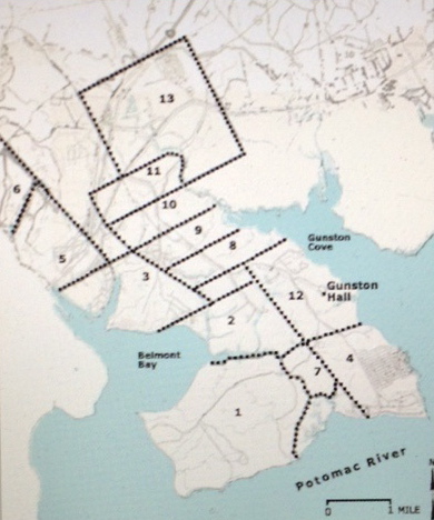
The original land patents on Doegs Neck, 1651-1666, are enumerated. The ledger below identifies the owner of each parcel. #10 is Peeter Smith of the Potomoc.
1 Robert Tenney 1651 2109 acres
2 John Jenkin 1653 1000 acres
3 Gervais Dodson 1653 1300 acres
4 Thomas Speake 1653 1000 acres
5 Richard Boren 1654 650 acres
6 Miles Cary 1654 3000 acres
7 John Mottrom 1654 360 acres
8 John Gosnell 1657 500 acres
9 Wm. Newberry 1654 500 acres
10 Peeter Smith 1657 500 acres
11 Thomas Molten 1657 500 acres
12 Richard Bushrod 1660 2000 acres
13 Scarlett 1666 2550 acres
Moxham assures us that original boundaries were eventually surveyed, and their correct position established for posterity. The location of each patent with respect to adjoining patents is thought to be correct, but he does advise “boundaries are highly speculative, in several instances.” The first patent north of the Occoquan River was given July 8th, in 1651 to Robert Turney (1), for 2109 acres at the junction of the Occoquan and Potomac Rivers. Turney referred to the tract as “Doggs Island.” That name is more frequently spelled ‘Doegs’ and appears often in descriptions of land deeded along the Occoquan and Rappahannock Rivers.
I have not been able to determine how long Peeter possessed Lot 10 on Doegs Neck. Was it his homestead or a prime investment property for which he held title? The inadequate patent descriptions that (140 years later) led George Mason IV to complain and my eyes to prolapse, led to a century of legal conflicts among neighbors, friends and family. The records and surveys that resulted from courtroom battles have been partially preserved and allow a researcher to reconstruct the Doegs Neck colonial boundaries with a fair degree of confidence.
The descriptions found in these original deeds were bound to lead to conflict and fail. Trees used as landmarks were going to die and fall. Brooks would dry up, disappear or alter course. The courts intervened and determined where boundary lines should be drawn. Colonial land law required that a guy like Peeter (a patentee) plant the land in crops and make improvements within three years. If the patentee (land holder) failed to plant a crop or make improvements, the property was ‘deemed escheated’ and available to the next claimant. There were many abandoned lands. It looked like Detroit for a time, without the smokestacks.
When Peeter bought these 500 acres in the ‘Petomeck freshes’ (marshland) he had no idea he was sitting on land that would be consumed by the urban sprawl of Washington D.C. The United States were 150 years down the road. The namesake of the future capital, George Washington, was a century away from his debut as a rock star on planet Earth. Washington’s DNA was coursing through the life stream of his great grandparents who were already lodged in the neighborhood, mixing it up with the Smiths, Bonums, Philpotts, Walkers and Lees.
Peeter’s land holding on Doeg’s Neck was the future homestead of George Mason IV. Peeter’s initial investment on the Neck would eventually be bought and sold and eventually acquired by George Mason I on his way to creating an elaborate plantation system. Who was George Mason IV? Let’s go to Wikipedia and allow me to steal a quick biography.
“George Mason (sometimes referred to as George Mason IV) (December 11, 1725 – October 7, 1792) was a Virginia planter, politician, and a delegate to the U.S. Constitutional Convention of 1787, one of three men who refused to sign. His writings, including substantial portions of the Fairfax Resolves of 1774, the Virginia Declaration of Rights of 1776, and his Objections to this Constitution of Government (1787) in opposition to ratification of the constitution, have been a significant influence on political thought and events. The Virginia Declaration of Rights served as a basis for the United States Bill of Rights, of which he has been deemed the father.”
When I taught history, George Mason was one of my favorite Revolutionary War heroes. Little did I know at the time he worked closely with my great uncles in Fairfax County on issues related to Freedom of Religion. It was George Mason and several other guys who pushed the Bill of Rights into place. He was a neighbor to Peeter’s descendants, a family attorney and a judicator in a court case that pitted brother against brother in a Smith property dispute. This Doeg property purchased by Peeter is identified in Table I as Lot #10. His 500 acres rests at that point where the Pohick Creek joins Gunston Cove on the Potomac River. The family plantations of the four generations of George Masons occupied the Doeg peninsula for more than a century. The name Doegs Neck gave way to Mason Neck, a promontory bounded on three sides by the Occoquan and Potomac Rivers and Pohick Creek. Moxham reports that
“Mason Neck was patented by adventurers who travelled up the Occoquan River and Pohick Creek which gave access to the land between. The dimensions of the Neck are such that it could accommodate one tier of moderately-sized claims parallel to each waterway, with the tracts having a common boundary along the median of the Neck.”
The Doegs were an Algonquin speaking, Native American nation that had flourished in the area prior to the devastation brought on by European disease. The island and neck were also called Miomspses (AKA: Myampses or Moyumpse).
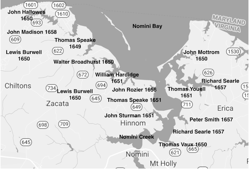
As if to illustrate the point that incompetence reigned supreme in the Virginia Land office the distribution of lands along the Occuquan River created more confusion. There were at least two interfering sets of patents for the entire area, and four patents for the same land were given over a period of about 20 years. Our Smiths (if our premise holds true) are found in the company of Colonel Thomas Speakes on both Doegs Neck and on a separate property to the south on Nominy Bay, Westmoreland County. The first land deeded on the Pohick Creek side of the Doegs Neck, 1000 acres at the mouth of that stream, was entered by Col. Thomas Speake in September 1653. Moxham notes that
“four years passed before Pohick Creek again attracted land-seekers, at which time four adventurers took up a tier of claims above (upstream from) Col. Speake. They left about 1000 acres between themselves and Speake, which was later taken by Richard Bushrod in 1660.”
Peeter Smith was one of the “four adventurers” who “took up a tier of claims above Col. Speake.” The ‘four’ included Gosnell, Newberry and Molten, along with Peeter. This is how we begin identifying neighborhoods and business partners. People tended to band together and move together back in the day. Again, the variations on the spelling of names becomes a factor. Was Gosnell originally Gosnold? Were Molten, Moulten and Mottrom one in the same? Can it be assumed that Peeter was a correct spelling distinguished from Peter? Will any of these names be relevant in this quest?
Moxham believes many of the original Doegs Neck parcels (shown in Figure 1) were purchased by speculators, sold several times, abandoned and reissued to later claimants. It is not uncommon to find the word ‘escheated’ in the brief descriptions of deeds. Moxham’s point regarding frequent exchanges is illustrated by the following description of a Doegs Neck property adjacent to Peter Smith.
Stephen Robinson, “500 acres… beyond Col. Speakes land…upon Peter Smiths …. granted to Thomas Moulton… assigned to John Wood… who assigned to William Thomas…. by him assigned to William Betts, who gave and assigned to said Robinson…. Oct. 1665.”
This property went through 6 hands in a matter of 8 years if one counts the original patentee who sold to ‘Moulton.’ This rapid movement of land from hand to hand makes it difficult to trace family history and identify homesteads. You might ask, “Why is it important to identify a homestead from four hundred years ago?” Some of us get goosebumps standing on ground that was worked by our ancestors and others amongst us could, frankly, give a rat’s ass. I get goose bumps, literally. It happened to me in England, standing at my in-law’s Whittington Castle and again as I looked at the cathedral built by my ancient ancestor, Sir Roger de Montgomery (1070 AD). It puts things in perspective for me, for a moment, and then I crave local food.
Fifty years ago, Cat Stevens sang: “We are only dancing on this Earth for a short time.” It is a profound moment when I stand where my forefathers stood and wonder at the steps they took in life’s journey. What makes this particular find on Doegs Neck all the more remarkable is that Stephen Robinson‘s DNA more than likely passed through the centuries to my Aunt Margaret “Robbie” Robinson, the wife of my uncle Bill Smith, descendant of Peeter Smith. The Robinsons and Smiths shared common ground two centuries later in Posey County, Indiana.
To locate Doegs Neck and Peeter Smith’s 500 acres go to Google Earth and enter coordinates: 38°41’N 77°12’W. The peninsula is 20 miles to the south of downtown Washington D.C. near Woodbridge VA. I tried to include a screenshot from Google Earth, but it did not reprint well and only confused my team of proofreaders, including Wilbur Rancidbatch, whose eyes crossed at one point and rendered him useless. Enter the coordinates I have provided and bring your sand wedge. If you are golfing with me, expect to see a lot of sand.
Now that we have pinned down one of Peeter Smith’s investments let’s look at the guys he was hanging with in 1657. Their names were lined up, 1 through 13, on the previous Doegs Neck plat map. I must be honest. I am an old history teacher and I didn’t know squat about any of these 13 guys. Universities don’t press the names of these land speculators into the hippocampus of students required to take the Survey of American History class. The events Peter’s neighbors participated in escape the attention of a lot of scholars. They were the original venture capitalists, land speculators and developers who left their mark on the American landscape, economy and marketplace. In retrospect, they are the second tier of 17th Century corporate Britain, the guys that laid the foundation for the oligarchy that has become our nation.
Again, we aren’t assuming they built manor homes on their lots or developed condos, beachfront gazebos or attended lawn parties at the country club. However, this small population of men lived in a colony with fewer than 10,000 citizens and may have been drawn into events that allow us to develop a better sense of who they were as pioneers in someone else’s garden, trampling through someone else’s hunting ground.
Let’s start with John Mottrom in Lot 7
Mottram was my father’s 7th great step grandfather. He is often identified as the first Englishman to settle on the Northumberland/Westmoreland side of the Potomac River. His home was a refuge for Protestants fleeing Lord Calvert’s Catholic Maryland. His estate, Coan Hall, served as the first county seat of Northumberland County. He presided over the county court for more than four years until his death in 1655. He was the first burgess serving Northumberland County in the Virginia House of Burgesses. As Northumberland grew in population, the county of Westmoreland was carved out of the northwest end of the Great Neck.
Doegs Neck was a late addition to Mottrom’s property portfolio. He also owned property along or near the Great Wicomico River and the Chickacoan River. He owned land on or close to Hull, King’s, and Chickacoan creeks. Like a lot of the plantation owners up and down the river and bay, Mottrom was a multifaceted planter and merchant owning his own shallop (a merchant’s sailboat). From his position on the Potomoc he established a profitable trade with Maryland. He was an old fellow in the Nominy Bay neighborhood and a bit of a rebel to boot. That boat out there on the end of his pier was used for more than just trade. During the final decade of his life (d 1655) Mottrom engaged in one war against Natives on the frontier and a rebellion against Governor Calvert in Maryland, which has been recorded in history as Ingle’s Rebellion.
A merchant from York County, Virginia, Mottrom settled on the Chicacoan River and established an early trading post. An Indian attack occurred on Holy Thursday, April 18, 1644, which killed roughly 500 settlers, a larger slaughter than occurred in Jamestown in 1622. A war ensued, which usually happens when you massacre 500 folks. To put things in perspective, Maryland had about 600 settlers in 1644. A lot of them were now dead. The war with the Natives lasted for two years off and on, now and then, here and there.
As part of a peace treaty signed in October 1646, the Virginians again promised not to settle on the Middle Peninsula and Northern Neck. The British and the Colony of Virginia decided that any white guy living on the far shore of the Rhappahonnock River was crazy and deserved to die. They promised the Native population that they, the Brits, would leave that parcel of property alone. “Right,” the Natives muttered, “We’ve heard that before!” Consequently, the earliest white settlers at Chicacoan, including Mottrom, were there on their own, independent of any Virginia government protection. There were no taxes, no Justices or Sheriff – no official authority of any kind. This is where the NRA mantra, ‘My Gun is the Law’ got started. It was a great place for Ayn Rand, Rand Paul and their Libertarian followers.
Within two years the Colony of Virginia abrogated the 1646 treaty with the Chicacoan Indians and annexed the entire Northern Neck establishing the County of Northumberland in January of 1648. While keeping one eye on his Virginia assets, Mottrom maintained an equal focus on his business operations in Maryland, just across the Potomac River in St. Marys. Life was in a state of chaos in Maryland as well. Mottrom and his protestant business partners were concerned about the predilections of Lord Calvert, the Roman Catholic CEO of Maryland.
John Mottrom is found in our family tree as one of several husbands of my eighth great grandmother, a character by the name of Ursula Bysshe. Ursula had a habit of picking men who had about five years left in the tank. Richard Thompson (d 1649), John Mottrom (d 1655), and Major George Colcough (d 1663) all supported the woman in the manner she preferred. Richard Thompson is my father’s seventh great grandfather. The other two guys, including Mottrom, would be step great grandfathers.
Mottrom was first married to a Mary Spencer and had at least three children by her: Ann (1639-1707), John Jr. (1642-?) and Frances (1645–1720). The Spencers also bump into our Smiths along the way. They had to, it wasn’t like the peninsula was overrun with people. I would like to come back to this extended family a little later to show you just how inter-married a British family lodged into a small peninsula can become. It’s an amazing and veritable Gordian Knot.
Colonel Thomas Speake, Lot 4
Also found in our extended family. The Colonel’s great great granddaughter, Elizabeth, was the first wife of our Peter Smith of Round Hill. She died young, without child, and Peter then married Jemima Simpson. The Colonel was born in Hazelbury, Wiltshire, England in 1622 and arrived in Virginia in 1639. The Speakes family of Wiltshire was wealthy. A descendant in Speake’s family, Ann, married Lord North, the Prime Minister of England who earned the scorn of the colonies heading into the Revolutionary War. Colonel Speakes had been dead and buried for a good century before Ann’s wedding to North, so he (the Colonel) never got the invite!
Speakes was a devout Catholic and first settled in Maryland, Lord Calvert’s refuge for Catholics. The Ingles Rebellion of 1644/45 may have driven him over the edge as he soon moved across the Potomac, into Westmoreland County where he began acquiring land faster than a buck in rut. Speakes was also a Royalist, whose support for the monarch was unflinching. This made him an oddity as Catholic Royalists were considered walking contradictions, oxymorons.
In 1642, Speakes and William Hardidge were 2 of 13 soldiers responsible for clearing Natives from Kent Island in the Potomoc River. You might think it odd that only 13 guys were needed to clear a tribe from an island. Keep in mind Smallpox had reduced tribal populations by as much as 99 percent, leaving remnants of once festive and flourishing villages to die in squalor. Clearing the island was more like clearing the homeless off the streets of a New Jersey city. Hardidge was one of Mottrom’s accomplices in the Ingles Rebellion. Speakes was not an accomplice. Speakes and Hardidge became neighbors on Nomini Bay. Hardidge’s son, Richard, married the widow Speakes and became her fifth and final husband. She too, like Ursula Bysshe, had a propensity for robbing the cradle or the grave, if either possessed wealth. Ingles rebels, John Rosier, William Baldridge and Lewis Burwell owned plantations adjacent to Colonel Speakes in Nomini Bay.
Speakes acquired two tracts of land, each in prime locations: The 600-acre Currioman plantation on the bay of the same name and the 400-acre Nomini Hall on Nomini Bay. Our Peter Smith Sr. lived near Speakes on Nomini Bay and also owned lot 10 near Speakes at Doegs Neck. Neither man appears to have developed Doegs Neck deeds and Speakes appears to have allowed his to be declared escheat in 1657. Both men were sons of the Wiltshire region in England.
Richard Bushrod, Lot 12
Richard was the second son of Richard Bushrod, an English merchant and explorer. Junior’s son John purchased land on Nomini Bay that became Bushfield Plantation. John Bushrod willed the Bushfield Plantation to his son, John Bushrod II. John Bushrod II had two daughters, Hannah & Elizabeth. Hannah became his heir and inherited the Bushfield Plantation. By the time her father had died, Hannah had married John Augustine Washington, brother of President Washington.
Myles Cary, Lot 6
Cary (b 1623) in Bristol, England, was the son of a woolen draper, John Cary. The English Civil Wars divided the family and Cary’s father suffered substantial losses in the woolen industry. As a result, Cary became involved in the tobacco trade and moved to Virginia in the 1640s. His name first surfaces in a 1645 deposition citing him for shorting a guy 250 pounds of tobacco. Tobacco was currency in the colony. Cary initially resided in the Warwick County household of Thomas Taylor, who may have been a kinsman, and by 1646 he married Taylor’s daughter Anne. Several points common to Peter Smith’s family line appear here: the wool industry background that Myles and Peter may share, an English Civil War that sent them off in the direction of Westmoreland and there is the tie into the Taylor family, one hundred years prior to James Smith’s marriage to Elizabeth Taylor. The point being that it was a small population in Westmoreland at the time and one big family.
Peter Smith of Yeocomico and the Westmoreland Neighborhood 1650
I have been hard pressed to find the affiliation of Peter Jr of Yeocomico or his son James with any church. I researched the minutes of any available online collections of the Nominy Church, Yeocomico Church and a few other churches in the county in the early decades of the 1700’s. I could not find one of my Smiths listed on the scrolls of a church. Paperwork simply does not exist for some decades. You might suggest that Peter was an atheist and I would say, “There is not a chance, that he would have revealsed that, not in the 1600s and early 1700s!” A man had to have a church and had to attend that church. It wasn’t some loosely held community norm. It was often the law. Attendance was taken. A guy could be fined heavily for missing a Sunday meeting, physically punished and humiliated in the stocks at the next week’s service. It made for great family fun on Saturday night just picturing what Old Man Wallace might look like in the stocks on Sunday morning!
Identifying a religious affiliation could help me locate Peter’s roots in the British Isles. It might provide an insight into why he, or his predecessors came to the colonies. Failing to find a religious affiliation for Peter caused me to look in the direction of his neighborhood. Was there a migration pattern in Westmoreland County? Did the first tenants share a common history that might help frame the context for the life of Peter Smith?
The first evidence of religious leanings in the early Nominy Bay community in which Peter lived, was provided by guys like John Mottrom, Thomas Youell, Robert Smith and Nathaniel Pope. This band of protestant freedom fighters and rebels engaged in Ingles Rebellion in Maryland (1645) and retreated to the Westmoreland shoreline along the Potomac River. We met John Mottrom previously in our review of Doegs Neck. He was invested in properties alongside those of Peeter Smith and Peeter’s investment partners (Gosnold and company).
Author’s Note: Anyway, I digress. I must get out and stretch my legs and empty my bladder. I have had way too much coffee! I might shoot some clay pigeons while I am away from my desk. Blind Billy Dawson just showed up on the back steps with his new Ruger Red Label Over Under 12 gauge and he wants me to verify that he still has enough eyesight left to hit a clay pigeon. To keep this conversation moving forward I am going to insert an excerpt from a recent presentation I provided at the National Convention for Smith Stalkers of America (NCSSA), whose motto, “We uncover the dirt you tried to bury!” is fast becoming the catch phrase for politicians around the world. I am feeling lazy and find it easy to just drop a partial transcript of my presentation in here. I haven’t had time to edit it. I apologize in advance if anything crude or unseemly gets into this manuscript. But frankly, nature calls.
Editor’s Note: Doc will do this to me once in a great while. He left a huge James Joyce styled void in this manuscript. Alongside the gaping hole of empty pages, he scribbled, and I quote: “Transcribe and edit 12/27 Vancouver audiotape. Insert here.” My reaction as his editor was shock and horror, in that order. And then it occurred to me: I won’t edit anything out of the tape recording of that Vancouver fiasco. This is my revenge. I am printing everything verbatim.
In the Name of God
The following is a transcript of a Powerpoint Discussion of Religious Strife in Maryland and Westmoreland, 1645 and Possible Impact on the Life of Peter Smith of Yeocomico. Presented 12/27/2015, to an audience at the National Convention for Smith Stalkers of America (NCSSA). Dr. Smith presenting:
“I hope you all enjoyed the break and found your way to the bathrooms and refreshments. Those of you with the appropriate medical prescriptions seem lighter on your feet now.” There is a long pause in the transcript as people take their seats. The usual banter can be heard in the background. One woman complains loudly about the long line at the bathroom. Smith then can be heard muttering into his microphone: “Pardon? A chocolate mint? No thank you but thanks for offering. Those things give me gas”. There is another pause before Smith begins in earnest.
“Before the break, I was talking about Oliver Cromwell and the Civil War in England in the 1640s and Ingles Rebellion in Maryland at that same time. The bloodshed on both sides of the ocean appears to have had a tremendous impact on Smith ancestors, neighbors and friends. The war in England was a basic, lusty grab for power by the upstart Cromwell and the Parliamentarians (Puritans) who took on the heavily favored Royalists (Church of England). Cromwell was able to overcome the odds in Las Vegas and went on to post both a victory and the head of King Charles I, adding new meaning to the title “Head of State.” It was a protestant against protestant grudge match fought for control of the British nation. Catholics invented Bingo as a form of diversion and laid low for the moment, while Anglicans, Presbyterians, Episcopalians and protestants in general, duked it out.”
“The long and the short of Ingles’ Rebellion is basically this: The Civil War in England spilled over into the colonies, specifically Maryland. The colony had been organized under the direction of Lord Calvert for the expressed purpose of providing a place on Earth where England’s Roman Catholic minority would be tolerated. Catholics in England were caught between two warring forces; the Anglican henchman Archbishop Laud and the Puritan death squads of Oliver Cromwell.”
“Governor Calvert wanted his private Maryland to accept various religious denominations as long as they were Christian. That seemed fair enough. He preferred Roman Catholics as he wanted Maryland to become a haven for Catholic Aristocrats fleeing the horrors of life in England. He pictured himself genuflecting with well healed Latin speaking scholars in vibrant Bingo games going late into the night in the pounding surf of his Mid Atlantic playground. He was one of the first in the New World to encourage a short-lived tolerance of various Christian denominations.”
“The desire to provide something for everyone pushed Maryland into a crisis. Having Catholics on the same block with the Protestants was a bit like opening a Dunkin Donuts and a Starbucks in the same neighborhood. It signaled an openness to variety and diversity. Folks began flocking across the border from Virginia. Maryland went from mostly Roman Catholic to more Protestant than not. Keep in mind the year was 1643 and we are talking about an Anglo population no larger than 600 citizens, the size of a large town in Nebraska.”
“As the protestant population grew, they became the majority population and clamored for control of the Maryland colony’s government. They would not accept mere toleration. In fact, they wanted to not only rule the bloody Papists, they wanted to get rid of Lord Calvert’s Toleration Act and end the toleration of Catholics.”
“It was in this political climate that men like Richard Ingle rose to power. Over the course of several years, beginning in 1642, a handful of Puritan ‘merchants’ from Virginia crossed Chesapeake Bay and implemented a three-point plan: “
–They established a port city on the Maryland side of the bay.
–William Claiborne seized control of Kent Island, taking it from Catholic Maryland
–Richard Ingle captured Maryland’s capital city, St. Marys, and chased Lord Calvert, momentarily, off to Virginia.
“The dispute over Kent Island escalated into an armed conflict now known as the ‘Plundering Time.’ The disgruntled Maryland Protestants plotted their rebellion against Governor Calvert at John Mottrom’s house. After Lord Calvert subdued the rebellion in late 1646, the rebels initially fled back to Mottrom’s house on Nominy Bay. Many of the prominent participants in Ingle’s Rebellion settled into the Nominy Bay neighborhood with legitimate Westmoreland deeds beginning in July 1653. I introduced John Mottram to you before our break this morning. He married into the Smith family tree when he hitched his wagon to my 8th great grandmother, Ursula Bysshe in Northumberland Virginia. Bysshe was the widow of Richard Thompson, a man who had worked for Claiborne, participated in the Rebellion as Claiborne’s henchman and was convicted of crimes against Maryland. He was banished with everyone else to Virginia. Thompson is my eighth great grandparent along with Ursula.”
“Protestants greatly outnumbered the Catholics in Maryland and Calvert’s position was dubious at best. But the Catholics were not immediately overwhelmed. Calvert had time to construct St. Thomas Fort on the property of Giles Brent’s sisters: Margaret and Mary Brent. The Protestants constructed a fort around Nathaniel Pope’s house. Game on! Let’s all play Stratego. The ‘battle’ became one of raids and foraging to support each garrison. A poor old woman named Blanche Oliver lost an ox to Calvert supporters at St. Thomas Fort and a cow to the rebels at Pope’s Fort. The following week her oxless cart had a cute bumper sticker reading ‘Stop the War!’ “
“ ‘Warfare’ itself amounted to raids and counter-raids, each attacking the fort of the ‘enemy’. Theft and vandalism were usually followed by plunder and arson. Nobody really wanted to kill or be killed. There were only a handful of people in the new colony and they had come to know each other in their daily lives. There certainly weren’t enough people one could count as strangers worthy of killing without mercy. Occasionally a good Catholic (Thomas Cornwallis’s wife) would watch as her mansion burned to the ground at the hands of her old friends. A protestant might suffer similar consequences. Don’t get me wrong, it was hostile. Men were held hostage. Giles Brent was kidnapped and taken on board a ship and dragged to England to face trial. He was deprived of his property and ruined for a time. Being good pioneers of sturdy stock, folks would often bounce back from defeat, but often in a new location. Lord Calvert was somehow able to maintain some military control in Maryland and arrange a peace agreement with Mottrom, Claiborne, Robert Smith and others. They promised to stay out of Maryland for a time.”
“Please put slide 1 on the screen.” There was a long pause as the remote control failed.

Mottrom and Company put Maryland behind them.
“Gracias. Rebels boarded Mottrom’s shallop with their pardon from the Governor of Maryland in hand and sailed across the Potomac to their new digs on the far shore in Virginia. Rumors that they downed Giles Brent’s fine tequila and smoked Cornwallis’s fine Cuban cigars as they sailed are unfounded. We do know they kept an eye on Maryland politics for some time to come, established Westmoreland properties and lived the good life.”
“Nathaniel Pope’s love life created enough offspring that he eventually became our cousin and a great great grandfather of George Washington. No one had any idea that a skirmish with British aristocrats like Calvert would end a century later in guerrilla war that brought an end to the King’s rule in America. These not-so-little events (Ingles Rebellion) added up over time and gave the colonists a sense of bravado and self-respect in the face of England’s perceived lack of respect for the ungrateful hooligans over here in the colonies.”
“Mottrom’s Westmoreland neighborhood looked like this in the early 1650s. Slide 2 please.”
[Editor’s Note: There was about 5 minutes of sudden commotion in the conference room as technicians worked with the microphone, speaker system and overhead projector. Amid the growing chaos a woman can be heard choking and someone is shouting, “She’s choking, she’s choking.” While the technicians debated the issues related to the technical problem, an EMT rushed into the room and immediately applied the Heimlich Maneuver to the choking woman. A Cheetos flew from her mouth and the audience erupted in celebratory applause. The room grew quiet and one technician can be heard mumbling to another, “It wasn’t plugged in.”]
Dr. Smith then began speaking; “Alright, we have survived the calamity. Slide 2 please.”

Slide 2: Nomini Bay Homesteads of Mottrom & Co.
“I used little red flames on this Google Map to designate the locations of each of the rebel’s start up plantations in Westmoreland County.”
A voice from the back of the conference hall can be heard lecturing Smith: “If your book is printed in black and white the reader won’t get the full effect of the hot little red flames. What a shame that would be! They are such cute little flames. I love fire!” A nervous laughter fluttered through the audience. Smith can be heard whispering to the wait staff. “Someone, please! Remove the candles from that man’s table.”
Doc quickly removed the slide with ‘cute little flames’ and used the following slide, devoid of any flames.
Dr. Smith heard a chime sound emanating from his laptop and read an entry on his Twitter account.
“Someone in the audience has tweeted: ‘The snack bar is out of cherry soda, and the chips are also running low.’ Thank you for that update. Can someone please notify the front desk that we have a food crisis. Now. As I stated earlier in this presentation, the question of religious affiliation is important in understanding Peter of Yeocomico’s ancestors. A church affiliation may open other doors in the effort to establish Peter’s identity and our own heritage.”
“Producer’s voice: ‘We have a question coming in online now. I can read it to you: ‘Did the Smiths originally enter the New World through a port in Maryland or Pennsylvania or possibly a wormhole in a parallel universe?’”
Smith: “This question is, no doubt, coming in from someone on Reddit. I assume the person is one of my son’s friends. Yes, I have considered the fact that Peter may have entered via a neighboring colony. I have been looking at Virginia headright records that covered immigrants coming in from both foreign ports and neighboring colonies, including Maryland and Pennsylvania so I think I have all ports covered. I have not investigated the wormhole possibility.”
Producer: “Another question from here in the audience, Doc. If you don’t mind.”
Smith: “I do mind. But go ahead. The lady in the headdress who looks sort of like a Humboldt Penguin.” A gasp emanated from the audience; a loud collective gasp. Doc can then be heard sucking in air and trying to mask his embarrassment. He said somewhat apologetically, ‘Oh! You are a nun?’ there was a long pause and then he repeated what he had just heard, ‘Sister Barbara? Thank you, Sister.’ “
Sister Barbara: “Were the Smiths protestant or catholic? And why is it important for you to know?”
Smith: “Well Sister Barbara. The answer to your question might explain a motivation for leaving England. That’s why it is important to me. Was Peeter of Potomac (possible father of Peter of Yeocomico) a protestant and a participant in the Ingles rebellion? I mean, look at slide 2: Smith’s Nomini Bay neighborhood was home to the protestant ringleaders of Ingles Rebellion. Mottrom died in 1655, before Peeter settled in 1657, but these other guys were hanging around. Smith and Mottram did hold neighboring Doegs Neck properties. Was Peeter related to the Robert Smith who was a major player in the Ingles Rebellion? I don’t know. Robert Smith’s Last Will doesn’t indicate that he had a son or brother named Peter. But, maybe he was a cousin or uncle.”
“Or, was Peter a Catholic fleeing the turmoil in Maryland? Virginia was a refuge for families from all sides of the crisis. A neighbor in Doegs Neck and in Nominy, Colonel Speakes, a Catholic, moved into the Nominy neighborhood to flee the chaos in Maryland and he was welcomed in by both the Neighborhood Watch Committee and the W3 (Westmoreland Welcome Wagon). Was Peter of Yeocomico even in the colony at the time of Ingles Rebellion? I would bet Peter of Yeocomico had not even born yet. But Peeter of Potomac? That guy would fit the bill, or his father would. Or a guy who came in through some crazy wormhole. I don’t know. A wormhole? Of all the bizarre questions. I need coffee. I really do.” A commotion is heard as Smith inadvertently knocked a carafe of coffee unto the floor.
“Every once in a great while I reexamine deeds, plat maps and their descriptions and honestly ask myself: ‘Have I got the Smiths in the right location?’ I am open to second guessing and conducting more research as long as it involves liquid refreshment and charcuterie.”
Producer: “Doc, we have an email from NukeMeBaby@MadHatter.com. I can read it for you.”
Smith: “I would really rather you didn’t.”
Producer: “Doc?”
Smith: “I suppose in the name of chivalry and all that is nice and polite, you should read the question.”
Producer: “It reads: ‘I don’t recognize Virginia in that slide 3 thingy map thing you put up there. Do you have another map thingy that would maybe sort of make more sense to me?’”
Smith: “Slide 4 Please. I really hope this helps. I don’t know how much more I can take. This is Virginia and the arrow to the right points at Westmoreland County. Can you see that? My God! I hope so! I can’t make it much bigger than that.”
Producer: “We have one more question.”
Smith: “No! Not from Sister Barbara? No! Not right now. Sit down, Sister. Please set your laser pointer aside! That can torch a hole in a retina you know! Oh! Geeez! Ouch! Someone, please! Remove her from the room! Now!”
The conference ended on a sad note. A trip to the village clinic, too late in the day for emergency service, sent Doc packing for home with one eye covered in cotton swabs and an elastic bandage from a first aid box that had been opened once before “in the sixties,” he was assured. He skipped the dinner honoring a Smith family from Lexington, Kentucky whose research, A Smith Family Marine in the Invasion of Grenada, sparked a year of breakthrough documentation among family genealogists pursuing a high number of illegitimate children possessing Smith DNA in the Caribbean Islands, circa 1983.
