

Map of Jamestown Colony, Virginia in 1607.
Maps will enlarge if you click on them for better viewing. Use your back button to return to this page.
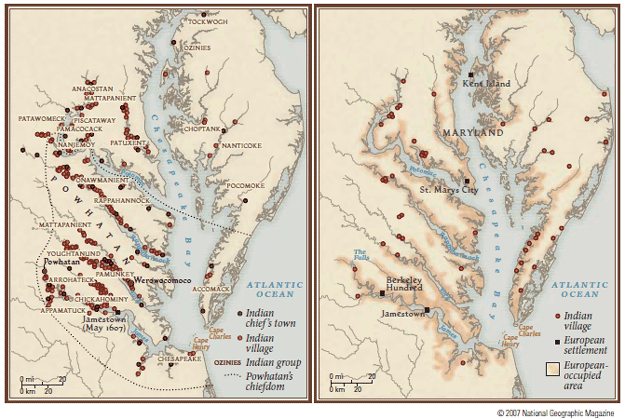
The end result of the labor of Sir Thomas Symth and his investment company, Jamestown was both success and failure wrapped up in one colossal effort. This map shows the location of the Jamestown Colony in Virginia. At that time the term ‘Virginia’ referred to the entire eastern seaboard from Newfoundland to the Spanish territory of Florida. Captain James Davis was responsible for providing supplies and settlers from England. He was captain of one of the nine ships that made up the entourage known as the Third Supply. He also captained the first ship built in the British colonies, along the Kennebec River in the failed Popham Colony of ‘Maine’. The 50 foot long pinnace, named Virginia was lost in a hurricane that wreaked havoc on the convoy to Jamestown. The Virginia arrived in Jamestown one year after the convoy.
The legend on this map indicates the many native villages located along the Chesapeake Bay and estuaries. The rapid decline of villages can be attributed to smallpox and the British policy of eradicating the Indians in a series of conflicts that each blamed on the other. For a sobering read on the impact of the European on world populations I recommend Guns, Germs and Steel by Jared Diamond. Our man, James Davis himself was an aggressive soldier and responsible for the construction and administration of forts. In that capacity he was also aggressive in attacks and counter attacks. His aggressive strategy conflicted with Captain John Smith, who, despite his historical reputation as a warrior, was also a shrewd diplomat when dealing with foreign populations that vastly outnumbered his forces. Davis had the support of Sir Thomas Smythe, London Company CFO, but both were retired from business related to Jamestown as the Company sought a new direction. Corporate profits needed to be made. Enough of this operating in the red, was pretty much the rallying cry in the company board room.
James Davis and Rachel Keyes Davis retired to a settlement on the opposite shore of Jamestown. His children and grandchildren migrated away from the James River and with other pioneers populated the lands to the south, via the Nansemond and leading eventually into the coastal plains of the Carolinas. Rumors that they opened the first 18 hole golf course on Myrtle Beach are false.
For more information about the early explorations of the seafaring Davis family go to The First Sea Captains and Jamestown.
The map below gives you and idea of where several of our early ancestors established their roots in Virginia. The Whittingtons hunkered down in Accomack on the Delmarva Peninsula. The Smiths and fellow ancestors were buying up land on the the Great Neck. Meanwhile, the Davis family began in Nansemond and headed south into the Carolinas. The Great Migration across the Blue Ridge brought all of the siblings and descendants of these various families together in Kentucky. The fact that a Stille with roots in New Sweden and New Netherlands would marry a gal from North Carolina makes a point that folks were not place bound, especially in a vast wilderness.

